Advertisement
Madeline weakens to tropical storm as nears Hawaii; Hermine approaches Florida

By Karin Stanton
KAILUA-KONA, Hawaii (Reuters) – Hurricane Madeline weakened to a tropical storm on Wednesday as it advanced toward Hawaii’s Big Island, while a hurricane warning was issued for another storm approaching the Gulf Coast of Florida, where the governor has called an emergency.
Strong winds and driving rain pounded both northwest Florida and Big Island as residents braced for even wilder weather.
Hawaii officials opened shelters and closed offices, schools and roads on Wednesday to prepare for Madeline, which is expected to pass just south of the Big Island.
“We should all be hunkering down as the storm passes,” said Hawaii County Civil Defense spokeswoman Kanani Aton.
Madeline, as it weakened with sustained winds of about 70 mph (113 kph) on Wednesday afternoon, was about 75 miles (121 km) southeast of the Big Island, said Central Pacific Hurricane Center meteorologist Ray Tanabe.
The tropical storm, before it moves westward out of reach of Hawaii, could dump as much as 15 inches (40 cm) of rain on parts of the Big Island, according to the National Weather Service. The storm already was lashing the island with rain and wind, resulting in some road closures, Tanabe said.
Hurricane Lester, currently a major Category 4 storm, could affect Hawaii over the weekend.
Hawaii Governor David Ige signed an emergency proclamation that runs through Sept. 9, freeing up state resources.
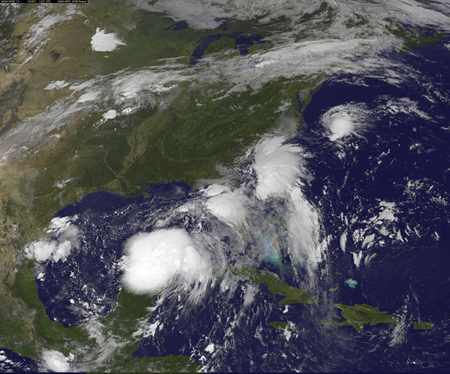
Meantime, the National Hurricane Center issued a hurricane warning for a portion of northwestern Florida as Tropical Storm Hermine continued to strengthen over the eastern Gulf of Mexico.
The system was located about 315 miles (510 kilometer) west-southwest of Tampa with maximum sustained winds of 60 mph (95 km/h), the Miami-based weather forecaster said late on Wednesday.
The NHC said additional strengthening is forecast during the next 24 to 36 hours, and Hermine is expected to be a hurricane as it reaches the Florida’s northern Gulf Coast by Thursday afternoon and then sweep across northern parts of the state with driving rain, then northeast along the Atlantic Coast.
Florida’s governor declared an emergency on Wednesday ahead of the brewing storm as many school districts along the Gulf Coast canceled after-school activities and ordered students to stay home on Thursday.
Heavy rains were already pounding parts of the state on Wednesday. As much as 20 inches (50 cm) could fall over northwest Florida, the NHC said, warning of storm surges and “life-threatening inundation.”
On its current path, the system would dump as much as 10 inches (25 cm) of rain on coastal areas of Georgia, which was under a tropical storm watch, and the Carolinas.
Lori Hebert, 40, woke up on Wednesday to flood waters seeping into her house in the Tampa Bay region. Catfish came onto her driveway as the street flooded in Gulfport, a small waterfront city.
“We haven’t gotten the main storm yet,” she said, loading a dozen sandbags into her van.
U.S. oil and gas producers in east of the Gulf of Mexico removed workers from 10 offshore platforms, moved drilling rigs and shut some output because of the storm.
(Additional reporting by Leticia Stein in Tampa, Brendan O’Brien in Milwaukee, Laila Kearney in New York, Alex Dobuzinskis in Los Angeles, Jon Herskovitz in Austin, Texas, and the Houston bureau; Editing by James Dalgleish, Leslie Adler and Simon Cameron-Moore)


